[Home][Scroll down to ALPHABETICAL INDEX for topics]


Sunday, May 31, 2015

Mawson Station - 67S/62E - Australia - lately known for Niburu videos.

The print on the map below is tiny but you can see Mawson at about 2:00 below, on the coast just "under" 45 deg. E. Longitude, east of the "prime meridian", the meridians being the longitude lines. It's important to know where Australia is as well. Notice that the entire "east side" from 2:00 to 5:00 is labelled "Australian Claim", so Australia must be just outside of that area. 
The next map is unique-- I've never seen this projection before. It clearly shows the meridians (lines of longitude) that project from Australia into Antarctica's Australian Claim. Note that Mawson Station is at the far East side of the claim, that Davis and Casey are also Australian stations and that "Commonwealth Bay" would define the Western station belonging to Australia. That's a very long stretch of the Antarctica coastline and Australia has one of the most extensive Antarctic government agencies on Earth. It should be relatively easily to get flights or ocean boat trips from Mawson to Commonwealth Bay to measure the TRUE length of that coast or distance-- vs. what they're telling us or what the Spheroid Longtitude Calculations tell us. 


  • Now let's take a look at Mawson from the point of view of my best flat earth map. The map is rotated so study it for a few minutes to get your orientation relative to, say, the Antarctic Peninsula which juts out noticeably... and Australia. 
  • Note Mawson is at about 2:00 as well on this map but that Australia is smaller and toward the "left" on the map, or at about 10:00. 
  • Note Australia's Claim from about Casey (11:00) to Mawson (2:00) with Davis in between. 
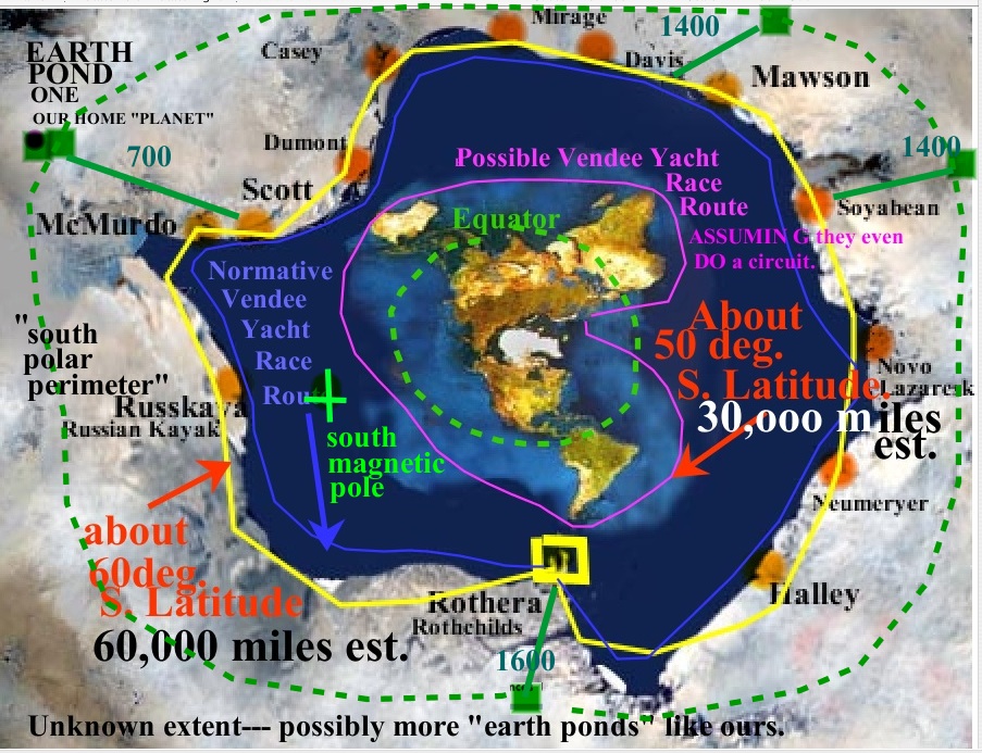
  • Note that the "official South Pole" is going to be to the left and upper left of Scott/McMurdo even though I forgot to put it on this map. The official South Pole is roughly where the label "Earth Pond One" is on the map below. 
  • Note where the official South Pole is with respect to Mawson. 


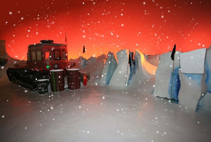
We're about to land at Mawson Station on the RumDoodle blue ice runway in a Twin Otter-- I think to deliver fuel drums. 


I'm not impressed by the Niburu videos that have exploded on Youtube when you search for Mawson Stations. The bright dots look like lens artifacts of an over exposed moon or other things. It's too bad Mawson video searches give us this now. At this point, I'm only interested in gaining flight, time and distance data from station to station to verify or deny the 60,000 mile circumference of a "rim Antarctica" as opposed to an "island Antarctica" of 15,000 miles or less.

I started this post with nothing on Mawson and will try posting my finds in real time here, indexed under Mawson Station 1 - Introduction in the index below. Here's the initial Google search with a few results of interest.
mawson station - Google Search


Mawson station — Australian Antarctic Division

www.antarctica.gov.au/living-and-working/stations/mawson

Dec 12, 2014 ... Mawson station. Location: 67° 36′ 10″ S, 62° 52′ 26″ E (−67.6027° S,62.8738° E). Mawson is situated on an isolated outcrop of rock on ...


Living at Mawson — Australian Antarctic Division

www.antarctica.gov.au/living-and-working/stations/mawson/living

The longest continuously operated station in Antarctica, Mawson was established in 1954. It was named after Australia's most significant Antarctic explorer, ...


Mawson Station - Wikipedia, the free encyclopedia

en.wikipedia.org/wiki/Mawson_Station

Mawson Station is one of three permanent Australian bases in the Australian Antarctic Territory of East Antarctica. Named after Antarctic explorer Sir Douglas ...
Purpose - ‎History - ‎Geography - ‎Climate

Note where RUMDOODLE blue ice runay is with respect to Mawson Station. We'll be landing there, virtually, below. 


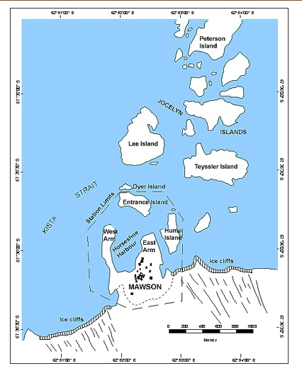
I didn't know that theree islands out in front of Mawson and the Mawson is surround by an ice wall, according to the following map.
v


 Amazingly, Mawson Station is like a university campus with an extensive layout. 
s
Same source as link above


Travel time from Mawson to Rothera.


The GREEN ARROWS indicate the official general direction of the trips from HOBART to Mawson, Davis and Casey. Note how "convenient" the trips are-- and note how there is no travel between the stations. There is absolutely no reference made to trips from Hobart to, say, McMurder, or Ruskaya or Halley at the bottom of this map. Not even Rothera. That's because, on a flat earth, the shortest rout from Hobart to Halley is over the NORTH pole! Otherwise, you'd have to travel 60,000/2 = 30,000 miles around half the ice wall to get there. It's just not worth it. And it's never done. On a ROUND spherical Earth, it should be a common occurrance. 


Saturday, May 30, 2015

Airplane routes argument for flat earth.

I've always thought the airplane routes argument was pretty interesting in supporting the possibility of a flat earth. I have not delved into it deeply on my own but rather have relied on video makers like the following to study. Now, with my Antarctica perimeter distance / time argument, this airline route argument becomes a little more interesting to me. What if I could do something similar for Antarctica as this video does for intercontintental flights? In a similar way, I'm attempting to find out what the travel times, directions and distances are around Antarctica itself or even within Antarctica. Give this particulalry good fast paced and well labelled video a go and then imagine viewing something similar for Antarctica. Maybe I can get the creator of this video to address Antarctica in the same way since I can't make videos like this.

I've invited Jungle Surfer to look at my proposition here.

Shipping stuff to and from Palmer Station done by Bamma

Everything in Antarctica at the stations has to be shipped in--- or out-- Nothing is indigenous. Here's a "cute' video by Beth Goodrich-- on Youtube showing how stuff at Palmer Station is shipped. My reason for posting this here is that maybe we can figure out REAL distances and times by a kind of tracking-of-stuff monitering by flat earth researchers. Everything SHOULD be travelling 4X as far and taking 4X as long as they tell us.. because a flat earth implies a 60,000 mile perimeter vs. an island on a ball which is 15,000 miles or less depending on whether you measure 60 deg S latitude or the shoreline as a mainstream figure-- it can be as low as 8,000. However, the exactness doesn't matter as much as the order of magnitude. And 15,000 X 4 = 60,000 so I'll stick with that. The following gets us "conditioned" to start thinking about how to track packages, including oil and jet fuel, around Antarctica. I've been running this blog for about a month and I'm beginning to understand that this task is not going to be simple. Nobody has approached Antarctica quite like I have, ever. Even the Flat Earthers. Even famous flat earthers like matt boyden and Eric.... eric... um... something. Eric banned me from his forum when I signed up and announced my intention. I posted to his blog and he never approved my messaged. I posted Matt's youtube video (one of them) and I don't think I have a response yet though I don't check back to some. I'm not getting anywhere.

Palmer Station tour of people with guitar music?


I'm on the hunt for personally made videos taking us on tours of various stations-- I'm with Palmer right now. I'm hoping to find a way to figure out how travel is conducted from one station to the next-- with the goal of travellling to all the stations. There's not much in this following video. The absense of useful information is becoming a key indicator of a cover-up, in my conspiracy minded mind.


If you click on the above video, you'll find my first comment about being a Flat Earth Researcher in the comments section as follows. I'll start posting these inquiries and links to this website to push a little deeper into this mission. I'm getting nowhere so far and I have to do something a little different. Anything. Maybe a bit of provocation will turn over a few rocks. We'll see.

Palmer Station on Antarctic Peninsula


I'll have to take a different approach because what I'm doing now isn't working. I can't find the distance around Antarctia-- via reports and airfield landings  because there is no data being reported. I'll start visiting each station and generate a feeling for what it's like at each point-- who the people are-- what the activities are. I'll start with Palmer.

OBSERVATIONS May 2015 by Rick

  • No mention of an airstrip in the video
  • Over emphasis as is typical, on environmental protection and studies
  • Weather ok on the peninsula
  • No mention of time of year in video but it's bright, so sun is up-- thus southern hemisphere summer - Oct to April
  • No diagram yet showing latitude
  • No mention of visitors from other stations
  • No mention of visitors from other countries
  • No tourists-- tourists only fly over icefields using Quantas, it seems, on other "side" 


Thursday, May 28, 2015

Dry valleys and warm lakes in Antarctica

Looks like only Americans at South Pole-- no sign of an international presence.

South Pole is  closest to McMurdo on the flat map as well as the sphere map. McMurdo is a US base. This video is a speech by a worker at South Pole. I found it fairly interesting in terms of everyday life there but also noted that there was no mention of tourists or techs and scientiest from other countries.

Raytheon in Antarctica

I picked up a factoid the other night on C2C on a show about chemtrails-- that Raytheon handles the radar systems around the world.  This reminded me of USGS handling mapmaking around the world. I also thought about Mark Sargent's and others pointing out that there is no GPS tracking of flights in the southern hemisphere.... however that point's importance is negated by the fact that pilots don't use GPS anyway. They use a tracking system installed by Raytheon. I wondered what Raytheon might be doing in the Antarctic which might help me determine the extent of Antarctica to see if it's an island or a perimeter.

Here's my search
http://www.google.com/search?hl=en&source=hp&q=raytheon+antarctica&btnG=Google+Search&gbv=2

Raytheon has "polar services" but this is inadequate for my purpose since the Antarctic is far different than the Arctic in both flat and sphere models.
Raytheon Polar Services Company - Home Page
rpsc.raytheon.com/‎
Raytheon Polar Services exists specifically to meet the needs of the National Science Foundation (NSF) Office of Polar Programs, providing support to the ...

Apparently Lockheed replaced Raytheon's functions...?
Lockheed takes over the U.S. government's Antarctic operations ...
www.westword.com/.../lockheed-takes-over-the-us-governments-antarctic- operations-keeps-staff-in-denver-5882797‎
Dec 28, 2011 ... Lockheed Martin takes over from Raytheon Polar Services, which has run the program since 1999. Although Raytheon bid on the contract ...

I'm not sure what the following means but here we find Raytheon hires everyone.
Employment in Antarctica - Darryn's Antarctica - Kulgun
antarctica.kulgun.net/Jobs/‎
This page will explain how to go about finding employment in Antarctica. ... Almost all the support positions positions are presently hired by Raytheon Polar ...

Communications is handled by Raytheon in Antarctica? What is NPOESS? It's not GPS. Are they going to tell us it's [fake] satellites?
Raytheon Completes First Phase of Communications Upgrade for ...
raytheon.mediaroom.com/index.php?s=43&item=929‎
Raytheon Completes First Phase of Communications Upgrade for NPOESS in Antarctica. AURORA, Colo., Feb. 27, 2008 /PRNewswire/ -- Raytheon Company ...


Here's a result that suggests that Raytheon gave way to the "U.S. Antarctic Program"
Work in Antarctica - Transitions Abroad
www.transitionsabroad.com/publications/.../workinantartica.shtml‎
Raytheon Polar Services (now The United States Antartic Program) has hires each austral summer to keep McMurdo Station—the main American base and the  ...


Raytheon is hiring Bloggers???
Job ad du jour: Raytheon needs writers in Antarctica - Boing Boing
boingboing.net/2006/03/10/job-ad-du-jour-rayth.html‎
Mar 10, 2006 ... Mil/Space/Aero contractor behemoth Raytheon is hiring "journalists" must for a year-long assignment in Antarctica. Bloggers accustomed to ...


Finally, I see the question asked that I asked this morning upon discovering Raytheon in Antarctica...
What is RAYTHEON really doing down in ANTARCTICA?? - Godlike ...
www.godlikeproductions.com/forum1/message1684322/pg1
Raytheon Polar Services Hmmmmm????? A DOD Military contractor that specializes in exoctic weapons and technology.

Raytheon prepped an area for the US Air Force
Raytheon Completes Upgrade in Antarctica for US Air Force ...
blog.executivebiz.com/.../raytheon-completes-upgrade-in-antarctica-for-us- air-force/‎
Jun 9, 2011 ... Raytheon has completed a major communications upgrade for the U.S. Air Force in Antarctica. This was done in support of future scientific and ...


Mark Sargent's Flat Earth Clues movie is probably useful to sit through.

Mark Sargent doesn't get to the proof of a flat earth earth here. The closest he came to a proof on Noori a few nights ago was the proposed experiment of 2 ships going in opposite directions meeting up in a week or a month. I don't know why he proposes 2 ships. Why not one ship going around Antarctica? It could even be a little above the Antarctic Circle. In any case, his movie is probably useful to watch. He gets into some really zany speculation which is fine. He uses the airplane routes in the southern hemisphere being switched off GPS as a key point which I guess is interesting and useful too. I didn't know that before I watched this. Do ships turn their GPS off too? He doesn't address that. I still like my circumnavigation idea with either ship or plane better as proof. 

Wednesday, May 27, 2015

Let's consider one section at a time of that 1968 study.


This is just a section from the study in the last post. Note the nautical miles for each stretch. These have been authoritatively documented by the study, apparently, so the work has already been done for me, here. All I have to do is verify it. 

For example, Halley to Sanae is 550 miles. (I'll dispense with the variance between nautical and statute for now since they're close enough, it won't make a difference to my analysis). 

Googling...
distance halley bay to senae - Google Search

I didn't find what I wanted on that search... but I DID find something about "gateway cities to Antarctica" which is interesting too.

  Cape Town, for many years a launching point for early sea explorations, is 
now one of five official ’gateway cities’ to Antartica, an international 

arrangement that is set to generate substantial economic benefits for the mother city. 

Rick says-- "official gateway cities" to Antarctica? Hmmm... this is interesting. Here's the source website.
Cape Town reaps benefits as gateway to Antarctica
https://www.capetown.gov.za/en/Pages/capetownreapsbenefitsasgatewaytoantarctica.aspx


MORE QUOTE from above
Along with Christchurch in New Zealand, Hobart in Australia, Ushuaia in Argentina and Punta Arenas in Chile, the City CapeTown has signed a statement of intent that binds it to jointly explore the benefits of academic and best practice exchange in respect of Antarctica. 
UNQUOTE 

Rick says... note that the city "binds" it to "best practice"-- which is questionable. What does that mean? If Antarctica is a perimeter around flat earth, this seems like flowery language to cover an enforcement mechanism to hide something. 

QUOTE
New Zealand’s most visited tourist attraction, the International Antarctic Centre, provides visitors with a simulated experience of Antarctica, including its storms, snow and ice,
UNQUOTE

Rick says... Who, in their right mind, would create a simulation of Antarctica when Antarctica is right next door by air with several flights a day now? The idea of a simulation points to the suspicion of a simulated GLOBE world to cover up the flat one, and the perimeter Antarctica. 

Here's a link to a Bing image search on the center.
international antarctic center - Bing Images


A few selected images I found particularly interesting...


Idiot tourists pretending to be shocked by cold 
air of simulated Antarctica


Completely inane simulation of an Antarctic tractor sorrounded by cardboard ice making it look like a movie set for "Lost in Space".


Real penguins trapped in a simulated Antarctica looked dazed, lost and confused. Can't blame them.

A display board that hypnotizes visitors into thinking that Antarctica is an island along with an unrealistic model of a sea lion on the floor.


24,000 visitors a year?
quote
Other tourism initiatives include catering for Antarctic-bound tourists. Most people get there by small or medium ship, and on arrival are flown onto the mainland to try their hand at mountaineering, skiing, or visiting the South Pole. The tourism market is big, with some 24 000 people visiting the continent via Ushuaia and Punta Arenas each year, despite the absence of any tourism infrastructure for them once they’ve arrived. 
Unquote

Rick points out.... No tourism infrastructure? So-- NO tourists can "tour" the many science stations-- but they CAN visit the simulation center. The science stations have a hotel quality to them sufficient for science and exploration teams throughout the year. Major facilities are being installed all over Antarctica for their work and yet there is NO TOURIST INFRASTRUCTURE. None. Nothing. No tourist has thought to VERIFY DISTANCES between research stations. 

quote
Instead, it is used exclusively for peaceful and scientific purposes by the 48 member countries, most of which have research bases there, including South Africa. Many visitors are attracted to it on account of its desolate, windswept icy beauty. In the 2007-2008 summer season, there were 46 265 visitors.
unquote


Rick repeats... 48 countries have bases... there were almost 50,000 visitors in 2007-08.  There is no tourist infrastructure. So... is there something wrong with this picture or is it just me? Of course, "they" claim there is no tourist facility to "protect the environment" and that Antarctica is key to Earth's weather-- yet the infrastructure for the bases is huge, extensive, impressive and quite stunning. Why can't "some tourists" visit the bases? Why isn't there a tourist trip to each base for limited numbers every year? But there is NOTHING. "They" say tourists are only interested in the stark no man's land isolation aspect of Antarctica. Only scientists are interested in the bases. Yet tourists (50,000) outnumber scientists (5000) by 10 to 1. Why can't each base have a section for visiting tourists from all walks of life? No. Tourists are effectively BANNED FROM BASES... except through MY VIRTUAL TOUR.
Uhhh... we sort of like tourists. We like everyone. What's the problem? 

Cape Town reaps benefits as gateway to Antarctica
https://www.capetown.gov.za/en/Pages/capetownreapsbenefitsasgatewaytoantarctica.aspx


Tuesday, May 26, 2015

Repeating Antarctica Airbus Network study will prove round or flat earth.


I'm repeating this information today because I think this most closely approximates what I had in mind when it occurred to me that we can prove Earth as flat or spheroid one way or another by travelling around the perimeter of Antarctica. There was an attempt to create a network of flights between airports as early as 1968 but it was not accomplished. Considering this network again might be the best way forward on my particular mission.


Airbus: an international air transportation system for Antarctica

https://s3.amazonaws.com/Antarctica/AJUS/.../AJUSvVIIIn1p16.pdf

It is feasible to build an en- larged facility on Seymour Island, and Argentine antarctic authorities are exploring ways of up-. 16. ANTARCTIC JOURNAL ...

More on John B. Dana, US Navy, author of the PDF Airbus article
https://www.google.com/search?q=%22john+b+dana%22+%22us+navy%22&btnG=Search&num=100&newwindow=1&safe=off&hl=en&gl=us&authuser=0&tbas=0

Sunday, May 24, 2015

Landing at a colony on the Antarctic Peninsula


I found this video engaging and realistic. It's simply some type of passenger jet landing at a colony called Aterrizaje on the peninsula that stretches up toward South America. I'd still like to do virtual take off's and landings around Antarctica's perimeter, hopscotching from one base to the next and measure distance based on calculations, reports or accounts. This post is toward that end.

Saturday, May 23, 2015

Russkaya has been abandoned?... according to Felix!


Open note to prolific commenter Felix-- If you give me an email, I'll include you as a co-author of this blog so you can make your own blog posts here. Russkaya being abandoned is "news to me"!

 For the other readers: Russkaya has been abandoned!!! It's in the sector of Antarctica that's NOT claimed... even though they say 9/10 of the PIE "is" claimed-- this ONE SECTOR is not-- it had ONE station-- or perhaps 2 stations with a US station further south-- but not on the coast. On the flat earth map, this sector is a very long stretch between the very popular and well visited "Rothera UK" base... and what looks to be a militarized US base at Scott/McMurdo. McMurdo and Rothera, in my mind now, are BOOKENDS that ISOLATE the South Magnetic Pole and a huge stretch of coastline. Russkaya was my ONLY HOPE of a landing for 1/4 of the way around the likely "fake island" of "antarctica". Thanks to Felix for this find. Here's his comment in another post.

felix has left a new comment on your post "Was Andhoy & his crew stopped?": 

I guess you noticed, Rick, that Russkaya was apparently "mothballed" in 1990 [wiki] allegedly due to funding problems.
https://ru.wikipedia.org/wiki/%D0%A0%D1%83%D1%81%D1%81%D0%BA%D0%B0%D1%8F_%28%D0%B0%D0%BD%D1%82%D0%B0%D1%80%D0%BA%D1%82%D0%B8%D1%87%D0%B5%D1%81%D0%BA%D0%B0%D1%8F_%D1%81%D1%82%D0%B0%D0%BD%D1%86%D0%B8%D1%8F%29
along with Molodyozhnaya [Молодёжная] and Leningradskaya and so doesn't appear on the list of facilities
http://web.archive.org/web/20070218093920/http://www.comnap.aq/facilities

There's evidence here that scientists from Germany's Technical University in Dresden have been working at Russkaya
http://eies.ats.aq/Ats.IE/ieGenRpt.aspx?idParty=17&period=1&idYear=2009
Permanent GPS observations at Russian Antarctic stations Leningradskaya and Russkaya; Scientific leader: Prof. Reinhard Dietrich
http://www.egu.eu/awards-medals/vening-meinesz/2014/reinhard-dietrich/

During the 2000s Dietrich had a hand in nearly every ESA/NASA mission pertaining to space geodetic observation of ice sheets 


Reinhard Dietrich.... Does he look like he would be up to living at Russkaya-- a no man's land in Antarctica? 


Antractic Circumpolar Current by Felix

Felix has been contributing valuable insights pertaining to this mission in comments sections in this blog  but I think some of them deserve their own indexing below so I'll include them in their own post when I can. This latest from him deals with the ostensible ocean current around Antarctica...

felix has left a new comment on your post "Was Andhoy & his crew stopped?": 

Somewhat unrelated, but I found this nice map of the Antarctic Circumpolar Current ACC the world's "largest ocean current"
http://jonova.s3.amazonaws.com/graphs/ocean/antarctic-circulation.gif

http://theresilientearth.com/?q=content/ocean-conveyor-belt-confounds-climate-science


It could easlily be adapated to an outer Antarctic circle model 

Once again, NASA is very active here
http://www.nasa.gov/vision/earth/lookingatearth/grace-images-20051220.html
http://www.nasa.gov/images/content/139807main_pic2-516.jpg

Most studies of the alleged circumpolar current have taken place in the Drake Passage, unsurprisingly.
http://oceancurrents.rsmas.miami.edu/southern/antarctic-cp.html
The Antarctic Circumpolar Current (ACC) as represented by the Mariano Global Surface Velocity Analysis (MGSVA). The ACC is poorly represented here because of the lack of data. The MGSVA is based on ship-drift estimates of sea surface velocities that are mostly available along major shipping routes. 
http://oceancurrents.rsmas.miami.edu/basin-maps.html
hmmmm

Here's another diagram from New Zealand showing the current
http://www.teara.govt.nz/files/m-5915-enz.jpg 

Was Andhoy & his crew stopped?


Apparently, private yachts going to Antarctica is indeed being seen now, by "authorities" as a big problem. A Norwegian adventurer, Jarles Andhoy, lost his yacht and 3 crew in Antarctica in 2011 and since then there's been a call to stop private yachts from exploring the "island" (perimeter of flat earth?).
Jarles himself survived with his son since they were on land headed to the south pole-- 1500 miles south.

From "Yachting World" magazine, I found this....

quote

www.yachtingworld.com/.../antarctic-deaths-enormous-ramifications-6330
Mar 11, 2011 ... There is likely be a clamp-down on yachts sailing to Antarctica ... their last reported position around ten hours after the distress signal, but found .
unquote

Note this again...

There is likely be a clamp-down on yachts sailing to Antarctica 

 Apparently, Jarles was exploring the area of the Ross Sea. Here's a map of the ISLAND (associated with global earth) and a map of the PERIMETER (associated with flat earth).


Notice that the Ross Sea... under the Ross Ice Shelf presumably-- is NOT in the sector that is devoid of stations--  which is where the article says Jorge Andhoy went. I'm still confused on this point. Andhoy's yacht was 17 miles from Scott... right in there with LOTS of stations within a close range.  Contradictions in the story and my understanding still have to be resolved-- suffice it to say that his mission led to calls for better control over private yacht explorers... that's a key point. Note as well that there is a Byrd (US) station south of Russkaya on the coast between .... Scott/McMurder and Rothera/FossilBluffs further north and east.


Note in the above map that Jorge Andhoy was actually very near Scott-- after all-- when he started to the "south pole". I've seen articles where it is said that McMurdo/Scott are the gateways to the south pole-- and that ALL missions to the south pole originate there. That would make sense on a flat earth perimeter antarctica as above.  Starting from Halley in the lower right doesn't makes sense although I've seens maps of missions to south pole from there as well... beyond resolution of this issue right now.  Note as well my approximate lines for the idiotic fake Vendee Yacht Race... in my opinion. How can yachts "race" around the approximate 50 degree latitude and still have food and supplies? It doesn't seem possible... .and a race makes no sense out on the dangerous high seas.... at least to me.


Rick says-- I've noted before that the area of the Ross Sea is devoid of airports, on this blog. I recently looked more carefully at the only station between Rothera and big installation at McMurdo (which DeNugent's readers are calling a military base)... the Russian Station-- Russkoya. I can't find a landing spot there yet. This stretch of territory might be much longer than the "island map" conveys to make up the extra [60,000-8,000 mile = 50,000 mile] coastline of the Perimeter-version of Antarctica. 

That article from Yachting World above reads as follows...

quote

The Ross Sea, where Andhøy and his companion were dropped off, is a part of the continent that hardly any sailors visit. This vast region is usually iced in until late February and refreezes in March.
unquote


Rick says-- Now why should that be? I mean-- why should it be any different THERE as opposed to the "other side" of the "island"?  Shouldn't freezes and thaws occur fairly regularly and evenly around the entire island, from winter through summer? Logically, you would think so. But apparently, this is not so. Furthermore, on either side of Ross Sea are Rothera, and around the the west, there's McMurdo-- both EASILY accessible. 

The Yachting World article continues and confirms my previous view...

quote

Unlike the Antarctic Peninsula, which sees between 30 and 40 visiting yachts each season, the Ross Sea offers very little shelter or protection and few places to get securely tied in.
unquote
Rick says... Well apparently the Russians don't neccessarily agree. They have a station Russkoya that I've been looking at. I'll post it to the alpha index below shortly-- and you can see it for yourself. You would think Jarles Andhoy would have made that station a definite stop on his tour. I certainly would. As well, Jarles Andhoy and crew apparently DID find a place to go ashore and got their vehicle land-bound too.

quote
Andhøy had not obtained the necessary permit to visit Antarctica and so did not comply with the due diligence and search and rescue plan entailed. He is reported to have loaded his yacht which, according to his website, displaces 25 tonnes with 5 tonnes of extra gear, including all terrain vehicles lashed on deck.

unquote
Source
Read more at http://www.yachtingworld.com/blogs/elaine-bunting/antarctic-deaths-enormous-ramifications-6330#aFVvcjJfxpoEpqEs.99

more quotes
“You have to apply to one of the Antarctic Treaty countries for a permit and you have to meet stringent environmental concerns, a search and rescue plan and you have to have insurance with a very high level of liability. If you don’t you can be prosecuted.”
Read more at http://www.yachtingworld.com/blogs/elaine-bunting/antarctic-deaths-enormous-ramifications-6330#aFVvcjJfxpoEpqEs.99
unquote

quote
He warns: “Yachts are seen by the Antarctic Treaty as loose cannons. They lurk around and go everywhere in self-mode. Cruise ships especially are looking out for yachts making mistakes,” Novak says.
Antarctic Treaty countries, which issue permits to their national vessels, are determined to crack down hard on yachts that flout regulations. The Norwegian Polar Institute, from which Andhøy should have obtained a permit, is prosecuting him and he is currently awaiting trial.
unquote

Rick points out-- Jarles and son got on land with their vehicle but left the others on the yacht who "were on their way back"... back where? To "Scott" which is next to McMurdo. This is a contradiction. Either they were on the coast at Ross Sea OR they were going out and BACK to Scott. Which was it? 
quote
Three yacht crew were lost in February when an expedition led by Norwegian sailor Jarle Andhøy, 34, went wrong.
The former naval diver and instructor for the Norwegian Rescue Company and a self-styled ‘wild Viking’ adventurer had led a crew of four from Christchurch, New Zealand to the Ross Sea in Antarctica on his 47ft steel yacht Berserk.
Here he and 18-year-old Samuel Massie disembarked with all terrain vehicles for a journey of almost 1,500 miles to the South Pole.
Those left on the yacht, Norwegians Robert Skaane, 34 and Tom Gisle Bellika, 36, and South African Leonard Banks, 32, were on their way back and only 17 miles north of the Scott Base when they met a storm and set off their EPIRB on 22 February.
unquote
Rick says-- Here's a 1 hour documentary of perhaps THIS VERY JOURNEY... or another similar one led by Jarles Andhoy. I'm unable to tell. I haven't watched the entirety of it yet but will post it now for my increasing numbers of readers to enjoy. My primary method for travelling around the perimeter of either the island or the plain-- is via air-- however lately, I've been reconsidering ocean travel and now I'm considering private yacht. Keep in mind the yacht race still exists and is conducted every 4 years from France--  which I currently believe is a hoax. Nonetheless, this yacht adventure is interesting. I'll also research EPIRB which I guess is an emergency channel of some sort. 


Latest Entries